No signal. No problem.
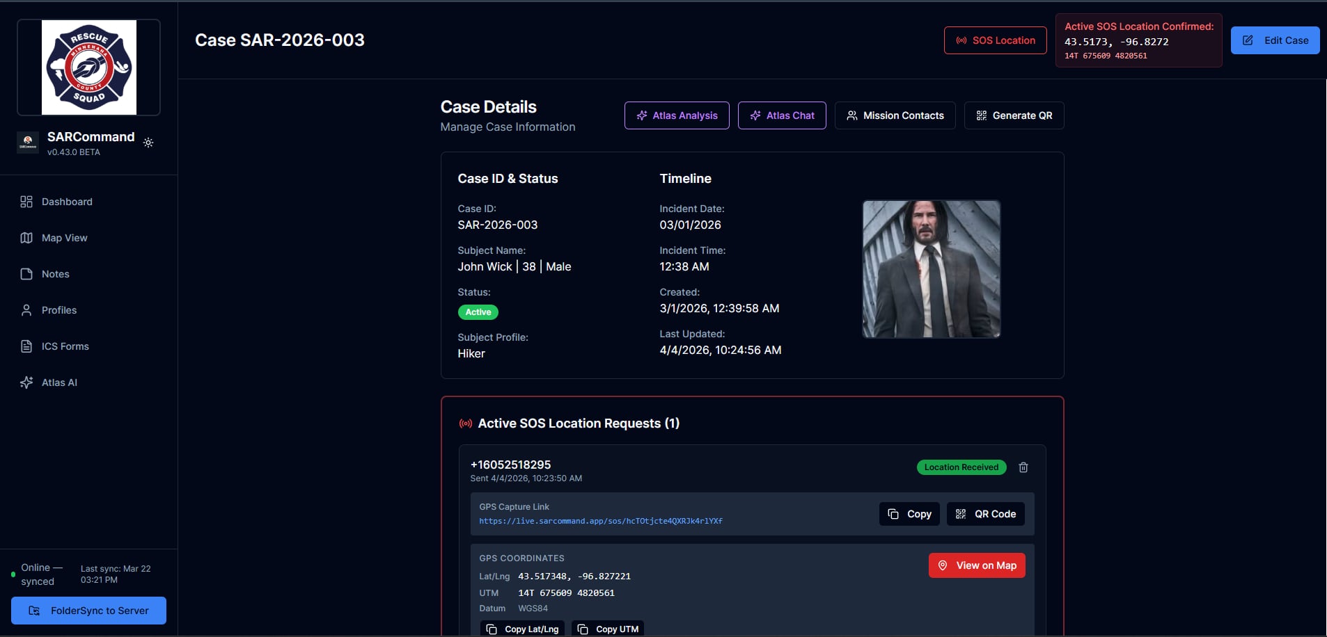
Offline-first search and rescue command post software. Manage cases, capture GPS locations via SMS, run AI analysis, and file ICS forms. With or without internet. One deployment. Ready in minutes.
Developed by Brian Skyberg, active SAR team member with field deployment experience.
In the field
A 14-year-old is two hours overdue from a day hike. Cell coverage is spotty. Your team is assembling.
This is the moment SAR Command was built for. Not a conference room. Not a stable network. The trailhead, with a laptop and a plan.
Create the case offline.
Subject details, LKP, physical description, medical info. Saved locally. No server needed.
Text a family member for their location.
SOS sends an SMS. They tap the link, grant GPS. Coordinates appear on your map. No app install.
Set probability rings and brief teams.
Statistical search zones based on subject profile. Share the case via QR code. Teams move out.
When signal returns, everything syncs.
Cases, notes, locations, attachments. Conflict detection keeps data clean across operators.
Incident commanders running multi-team searches from fixed or mobile command posts.
Reliable case tracking without enterprise infrastructure or IT departments.
County and regional agencies running ICS-compliant search operations.
Wilderness, rural, and urban environments where cell service is intermittent or absent.
Six integrated capabilities that replace spreadsheets, paper forms, and disconnected tools.
65+ field case record. Subject details, medical history, clothing, vehicle, emergency contacts, and interview data in one place.
Send an SMS. They tap the link. You get their GPS coordinates. No app install. No instructions. Just a location.
Works on any phone with a browser. The recipient grants GPS permission through a single web page — coordinates land on your map within seconds.
If they can receive a text, you can get their location.
All data stored locally in IndexedDB first. Work without internet. Sync automatically when connectivity returns. No data lost.
Interactive maps with LKP markers, SOS locations, and statistical probability rings based on Lost Person Behavior research.
GPT-4.1 analysis with full case context. Search strategy suggestions, risk assessments, and weather-aware recommendations via multi-turn chat.
13 standard Incident Command System forms. ICS-201 through ICS-221. Briefings, assignments, communications plans, safety messages.
A workflow built for the pace of real operations.
Subject details, LKP, physical description, medical info. Saves locally immediately. No server round-trip.
Share via QR code. Set probability rings on the map. Assign profiles and task checklists.
SOS location requests via SMS. Log notes, evidence, photos. AI analysis with live weather data.
Close with full documentation. Notes, locations, analysis, and attachments preserved for after-action review.
Every operation writes to local IndexedDB before reaching the server. When connectivity drops, you keep working. When it returns, sync happens automatically with conflict detection and transactional integrity.
SAR operations deserve better than spreadsheets, radio-only coordination, and tools that go down when you need them most.
Works at the trailhead, not just the office. No internet required for core operations.
Single process, minimal infrastructure. Operational in minutes, not days.
CSRF, encrypted auth, rate limiting, PII masking. Mission-critical security out of the box.
Not a generic project tool. Every feature exists because SAR operations demand it.
SAR Command is ready for teams who need a command post that works where it matters. Self-hosted. Your data stays yours.
Tested in the field. Built for missions that can't afford downtime.
Self-hosted. No vendor lock-in. Deploy on your own infrastructure.